People
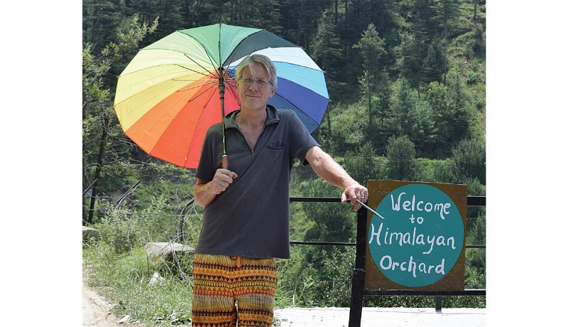

Before moving to Himachal in 2016, I lived in Japan. There, in 2009, I met my future wife. Her family has been living in the Kotkhai valley for many generations. I came to visit her family and ancestral farm in 2010 and was immediately taken by the idea of living in an orchard in the Himalaya.
The farm is situated at the top of a valley, with Shimla a couple of hours away, while a couple of steps across the road will place you in a serene and protected deodar forest. If you are somewhat robust, you could walk through the wilderness from our farm to the high passes of the Great Himalayas, and meet very few people along the way.
Ever since my wife and I moved here from Japan on Valentine’s Day 2016, we have been setting up a farm-stay alongside regular orchard work, which carries on regardless. We have many guests, many of whom go ‘trekking’. For some, this means a half-hour stroll along the road, while others would rather tackle a five-hour hike to the local peak from where they can sit and gaze at the lofty heights of Kinnaur, Kullu and, on a clear day, Uttarakhand.
I usually like to accompany them and point out that I am still in the process of learning about the socio-cultural and natural history of the area. When I can’t go with them, I send them off with instructions such as ‘turn left at the big pine tree’! Eventually, I decided to make a map, or a series of maps, of those hikes, which would make our guests feel more secure about navigating. Mainly, the routes are through the Kalala forest zone and are between 30 minutes and three hours long, but there are also day hikes of five to eight hours up to the local peaks of Neraghati, Reoghati, Chaal Temple and Sararu Pass. An overnight hike to Hatu Peak is planned.
We are lucky that an old mule track built in the British era passes through the forest, linking Kotkhai to Hatu, where it meets the Hindustan-Tibet Road. The aim is to create physical maps both on paper and online that correspond to marked trails on the ground. I also make stone cairns to mark the way. I first walk every path and discover whether or not they lead anywhere. Quite often, the paths simply dwindle into nothing but a clump of brambles. I then choose those that are worthy, especially ones with particularly good viewpoints along the way, or pass objects of interest, such as old water sources (bauri), a leper’s cave (where the victims were once apparently walled in), old boundary markers, trig points, etc.
One of our favourite picnic spots is a hanging rock known by the locals as ‘Saut ki dhankk’ on account of a story where two wives of a man were once sitting; one pushed the other, who grabbed the first, and they both fell to their doom. I also try to link up the routes so that round trips are possible. I then trace them using an app, which gives me an accurate record on Google maps. The majority of the work will be complete by the end of this year, but it is a never-ending process—there are always more paths to discover!
The more I walk these forest paths and the more familiar I become with the stories they have to tell, the more I realise that this is an exceptionally beautiful part of the world. It is not a place for everyone but it is the perfect place for those who like to ‘leave nothing but their footprints, and take nothing but their memories’.
—Michael Lidgley, Shimla
Photo courtesy: Michael Lidgley
Featured in Harmony — Celebrate Age Magazine
December 2017
you may also like to read
-

For the love of Sanskrit
During her 60s, if you had told Sushila A that she would be securing a doctorate in Sanskrit in the….

-

Style sensation
Meet Instagram star Moon Lin Cocking a snook at ageism, this nonagenarian Taiwanese woman is slaying street fashion like….
-

Beauty and her beast
Meet Instagram star Linda Rodin Most beauty and style influencers on Instagram hope to launch their beauty line someday…..
-

Cooking up a storm!
Meet Instagram star Shanthi Ramachandran In today’s web-fuelled world, you can now get recipes for your favourite dishes at….